Class 10 SST Map Work Notes: History and Geography for the Half-Yearly Exam
Class 10 SST map work carries 5 marks in the board exam: 2 marks from History's Nationalism in India chapter and 3 marks from Geography chapters covering Resources and Development, Water Resources, and Agriculture.

Table of Contents
- How Map Work Marks Are Distributed in the Board Exam
- Nationalism in India: Congress Sessions on the Map
- Nationalism in India: Gandhi's Three Satyagrahas
- Jallianwala Bagh, Chauri Chaura, and Dandi
- Resources and Development: Locating Soil Types
- Water Resources: Dams and Their Rivers
- Agriculture: Major Crop-Producing Areas

eSaral ›Foundation courses ›Class 10 SST Map Work Notes: History and Geography for the Half-Yearly Exam

How Map Work Marks Are Distributed in the Board Exam
The total map portion in Class 10 SST is worth 5 marks: 2 marks come from History, and 3 marks come from Geography. Questions in the paper are asked in two ways — either you're asked to locate a place, or you're asked to label it. The question paper always specifies which one is required, so there's no need to get confused between the two; whichever is asked, the location has to be correctly plotted on the map.
For extra practice with the exact board question format, past papers are worth going through on the CBSE Class 10 Previous Year Question Papers page.
Nationalism in India: Congress Sessions on the Map
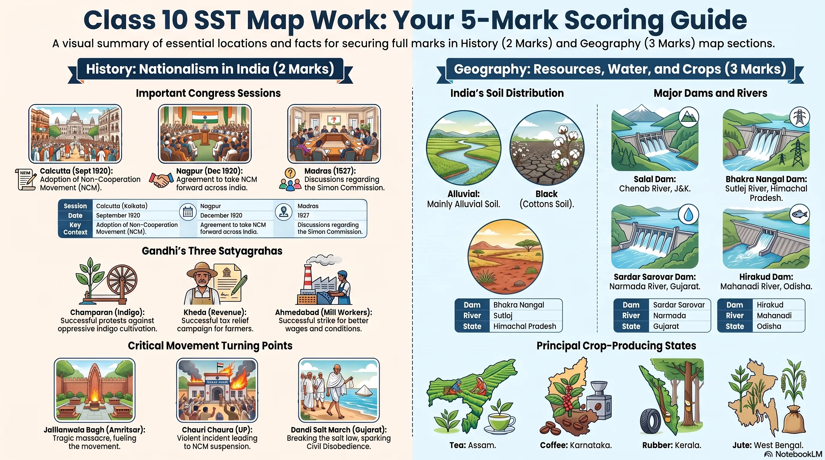
From the History chapter Nationalism in India, three Congress sessions are important for map work (an earlier Lahore session used to be included but has since been removed from this portion):
| Session | Location | State | Date | Context |
|---|---|---|---|---|
| Calcutta Session | Calcutta (Kolkata) | West Bengal | September 1920 | Mahatma Gandhi convinced the Congress to adopt the Non-Cooperation Movement (NCM) |
| Nagpur Session | Nagpur | Maharashtra | December 1920 | Congress agreed to support and take forward the NCM across India |
| Madras Session | Madras | Tamil Nadu | 1927 | Connected to the discussion around the Simon Commission |
Since both the Calcutta and Nagpur sessions took place in 1920, it's important to check the question carefully for whether a specific month is mentioned. If no month is given, Calcutta can be taken as the default for that year.
Nationalism in India: Gandhi's Three Satyagrahas
After returning to India from South Africa in 1915, Mahatma Gandhi organised three separate satyagrahas, each in a different location:
- Champaran, Bihar — This satyagraha was against the "teen kathia" system, under which farmers were compelled to grow indigo on roughly one-third of their land, which steadily reduced soil fertility. Farmers protested against this, and Gandhi organised the Champaran Satyagraha in response.
- Kheda, Gujarat — This was a satyagraha by peasants demanding a reduction in the revenue being collected from them by the British.
- Ahmedabad, Gujarat — This satyagraha involved cotton mill workers, whose demands were related to working hours and wages in the mills.
Gandhi was successful in all three satyagrahas. Note that Kheda and Ahmedabad are both located in Gujarat, while Champaran is in Bihar. The exact years of these three satyagrahas have appeared in MCQs in past papers, so it's worth confirming and remembering them individually alongside the locations.
Jallianwala Bagh, Chauri Chaura, and Dandi
Three more locations from this chapter come up regularly for map work:
- Jallianwala Bagh, Amritsar — The Jallianwala Bagh massacre took place on 13 April 1919, when General Dyer ordered firing on unarmed people.
- Chauri Chaura, Uttar Pradesh — Chauri Chaura is near Gorakhpur in Uttar Pradesh, an area that was a centre for the cloth trade. A protest against British repressive policies grew into a large crowd; accounts vary between 21 and 22 policemen being present, who locked themselves inside the police station, which was then set on fire. This incident, shown as an image in the NCERT textbook, led Mahatma Gandhi to call off the Non-Cooperation Movement, since he believed in non-violence and the incident had resulted in the deaths of the policemen inside.
- Dandi, Gujarat — This is the location associated with the Salt March. Dandi has appeared as a direct map question in board exams before.
For the original NCERT images and descriptions referenced for these events, the NCERT Books Class 10 page has the full textbook available.
Resources and Development: Locating Soil Types
Moving to Geography, the Resources and Development chapter includes a soil map with five soil types to identify:
- Forest soil — Found right at the top of the north of India, and also in the northeast.
- Arid soil — Found in Rajasthan.
- Alluvial soil — India's most fertile and most widely cultivated soil. Found mainly north of the Tropic of Cancer, in parts of Rajasthan, Madhya Pradesh, Gujarat, and Uttar Pradesh. It also appears as a strip along the eastern coast and in parts of the northeast.
- Black soil — Best known for growing cotton, and found mainly in Gujarat and Maharashtra, though NCERT's classification is broader and some southern states also have black soil.
- Laterite soil — Derived from the word "later," used for making bricks, and connected to the process of leaching. Found mainly as a strip along the western coast and also in parts of the northeast.
- Red and yellow soil — Found in the eastern part of the country, south of the Tropic of Cancer, opposite to where black soil is found on the western side.
The general rule to remember: north of the Tropic of Cancer is mainly alluvial soil; below it, the western part is mainly black soil and the eastern part is mainly red and yellow soil, with laterite forming a strip along the western coast. Practising this map by hand repeatedly is necessary to remember it well and score full marks, since map questions are considered scoring questions.
Water Resources: Dams and Their Rivers
The Water Resources chapter asks students to locate and label various dams. This portion can also appear as MCQs or "match the following" questions instead of a direct map question, so it needs to be prepared both ways.
| Dam | River | State |
|---|---|---|
| Salal Dam | Chenab | Jammu & Kashmir |
| Bhakra Nangal | Sutlej | Himachal Pradesh |
| Tehri Dam | Bhagirathi | Uttarakhand |
| Rana Pratap Sagar | Chambal | Rajasthan |
| Sardar Sarovar | Narmada | Gujarat |
| Hirakud | Mahanadi | Odisha |
| Nagarjuna Sagar | Krishna | Telangana & Andhra Pradesh border |
| Tungabhadra | Krishna (Tungabhadra) | Karnataka |
A few points worth keeping in mind: Rana Pratap Sagar should be marked in the correct part of Rajasthan rather than just anywhere within the state, and Sardar Sarovar Dam also connects back to the Class 10 Economics chapter on Development, where it's used as an example of how development can be beneficial for some and destructive for others.
Agriculture: Major Crop-Producing Areas
The Agriculture chapter's map portion focuses on the identification of major crop-growing regions rather than precise locating and labelling:
- Rice — Grown in the plains of north and northeast India, coastal areas, and delta regions. Canal irrigation and tube wells have also made rice cultivation possible in lower-rainfall areas such as Punjab, Haryana, western Uttar Pradesh, and parts of Rajasthan.
- Wheat — Grown mainly in northern India, including Rajasthan, Madhya Pradesh, Uttar Pradesh, Punjab, and Haryana — the same broad region north of the Tropic of Cancer. "Sharbati" wheat, often stored by households, is generally grown more in Madhya Pradesh.
- Sugarcane — Uttar Pradesh is the major producer.
- Tea — Assam.
- Coffee — Karnataka.
- Rubber — Kerala.
- Cotton — Maharashtra, connected to the black soil region discussed earlier.
- Jute — West Bengal, particularly around the Hooghly River, which is a recurring exam question in itself.
This covers the map portion expected up to the half-yearly exam from Nationalism in India, Resources and Development, Water Resources, and Agriculture. The remaining chapters' map work will be covered in a follow-up guide.
Frequently Asked Questions
Find answers to common questions.
How many marks does map work carry in Class 10 SST?
Map work carries 5 marks in total in the Class 10 SST board exam — 2 marks from History's Nationalism in India chapter and 3 marks from Geography chapters such as Resources and Development, Water Resources, and Agriculture.
Which Congress sessions are important for the Nationalism in India map?
Three sessions matter for map work: the Calcutta Session (September 1920), the Nagpur Session (December 1920) in Maharashtra, and the Madras Session (1927) in Tamil Nadu. The Lahore session is no longer part of this map portion.
Where did Gandhi's three satyagrahas take place?
Gandhi led the Champaran Satyagraha in Bihar against forced indigo cultivation, the Kheda Satyagraha in Gujarat over revenue collection from peasants, and the Ahmedabad Satyagraha in Gujarat involving cotton mill workers' wage and working-hour demands.
Which soil type is found in Rajasthan?
Arid soil is found in Rajasthan, while parts of the state also have alluvial soil, since Rajasthan lies partly north of the Tropic of Cancer, where alluvial soil is more common.
Which river is the Sardar Sarovar Dam built on?
The Sardar Sarovar Dam is built on the Narmada river in Gujarat, and it is also referenced in the Class 10 Economics chapter on Development as an example of development being beneficial for some and destructive for others.